Yet another time on McClellan Butte, and another time not making the summit. The first time I had been there, Jennifer and I hiked up the first summer we were in Seattle. In the last 500' or so before the summit it was snowing. When we arrived at the final summit scramble, it was too wet and slick for us to attempt.
This time the goal was to do the North Gully or North Couloir route. Avy conditions had been low and Steve, Julie and I were going to give it a try before more snow fell. However, we were thwarted by another individual that was in our vicinity. We were heading up the correct gully, and saw him heading farther west. Since none of us knew the route, we started heading west. After wandering around, we came back east, and eventually climbed the north west gully.
The climb was enjoyable, and had a very different flavor than what I would expect a spring ascent to have. From the parking area, the snow was bulletproof. No need to snow shoes. Almost a need for crampons. We hiked up the trail and veered off around 2800' heading directly toward the couloir. We found the abandoned road and continued up in the snow field below the gully. (Later, on descent, we would notice that we could have taken the trail all the way to the clearings below the gully.)
This is where we saw some woods above us. According to our pictures, the gully should be continuous, and this is also when we witnessed the lone individual heading farther west. We started going into the next gully, and then the next after that. We realized we were too far west, and headed back one gully and started up. This wasted some time, and it was around 11am when we stopped part way up the gully to have lunch. (There was a reasonably flat area, which we weren't sure we'd see too much more of.) With crampons and ax, we all soloed up to the top of the gully where the angle reached about 45° or more.
Steve then led out belayed up a short 3rd class rock step and more gentle snow. Things still looked promising for us to be summiting. Although where we were didn't look exactly like pictures we had. We took our crampons off and Steve led a belayed rock climb through snow and 5th class rock to a sub-summit of McClellan Butte. We could see the true summit and the correct gully. Which is much steeper for the last 200' or so. (Perhaps 60°) After Julie and I arrived on top it was close to 2pm, and we needed to get down. There were flurries in the air, and we weren't sure about the best way down. After a bit of down climbing on the hard steep snow, we rappelled a rope length, and more down climbing got us back into the gully we ascended. From there it was a slow climb down the gully, and a moderate hike out on the trail. We left the crampons on all the way to the car.
The correct gully
Overall, it was a fun time. I don't feel I climbed all that well, but I have been getting sick as Jennifer was sick most of the week. I haven't felt particularly strong because of it. Also, I was still recovering from last week's blisters. (I did a lot of work to the right foot, but none to the left foot before the climb. The left foot wound hurts more than it did this morning, while the right foot does not.) Also the McClellan Butte trail has some of the largest Douglas Firs I've seen in the I90 corridor. We saw some mountain lion tracks in the snow on the way down as well.
My pics are here.
Julie's pics are here.
Definition of best friend? They would let you KNOW when you had something in your teeth!
Saturday, September 27, 2008
Friday, September 26, 2008
Rainbow Sunset - Grand Portage Bay
This photo was taken last night at sunset just after a brief thunderstorm passed over Grand Portage Bay.
Thursday, September 25, 2008
Death Valley :: Ubehebe Crater
Wednesday, March 7th - - After stopping at Zabriske Point and the visitors center I drove the 60 miles or so to the north end of the park. On my last visit the road was under construction with long delays and I didn't have the patience to deal with it. I spent the night at Mesquite Spring Campground, which as rustic as it is, is one of the nicer campgrounds in the park – the campgrounds at Texas Spring, Sunset, and Stovepipe Wells are little more than parking lots with the campers lined up side by side.
Thursday, March 8th - - I was still quite tired from the drive on Tuesday and slowly got myself up and around this morning. Since I had never been in this area of the park before I took a look at the Visitor Guide. I knew Scotty's Castle was only a few miles away but wasn't aware that the Ubehebe Crater was even closer. (Ubehebe is pronounced u-bee hee-bee.)
The crater was formed about 2,000 years ago when hot, molten rock turned groundwater into steam. The intense steam pressure built until the superheated combination of steam and rock exploded. The explosion spewed shattered rock over a six-square-mile area, in some places to depths of 150 feet. Ubehebe is the largest of many explosion craters in the area – it is a half mile across and about 600 feet deep.
Several trails lead into the floor of the crater. I didn't even attempt to go down. You can't see them in the photo above, but there are two people down there.
See, there they are... barely visible at full zoom!
A trail also follows the crater rim, how long it is I don't know. I did follow the path up to another smaller crater, which according to a sign was half a mile distant.
A panoramic view of Ubehebe Crater. The parking lot is down that path on the left side of the crater, about half way into the picture. Be sure to double-click on the photo for a larger version, then click again when it opens – it is an incredible landscape.
Monday, September 22, 2008
Three O'Clock Rock Total Soul ..
Steve and I finally coordinated to get some climbing done. The goal was to head out to Darrington and get in a slabtastic time on the nice granite. We talked Sunday night and decided that our second attempt on Dreamer could wait, and we would head to 3 O' Clock Rock to see if we could accomplish multiple routes. We were headed there with the intent of climbing Total Soul (III, 5.10b?) and Silent Running (II, 5.9+?).
We got a late start and arrived at the trail head with no time pieces. We made quick time up the trail and stopped briefly to marvel at some cut tree trunks and a still standing western red cedar that had a 10'+ diameter at the base. Once at the base of the slabs, we made our way to the Total Soul route.
(Photo by Steve Machuga)
As we geared up, we discussed lead options, and I told Steve it didn't matter, I'd have to lead a 5.10 pitch no matter how we split them. So I told him to combine the first two pitches and give me the lead on the third pitch (a 5.7) so that could be my warm up lead. (Using the "Weekend Rock" topos.)
Looking down from two pitches up. (Photo by Steve Machuga)
Apparently I did need the warm up because after struggling to overcome one of the overlaps on the lower 5.9 section, I pulled on the draw to get over it. My lead went smoothly and soon Steve was leading the fourth pitch where the difficulty started to increase.
Starting the third pitch (Photo by Steve Machuga)
This was probably the hottest time on the slab as well. The sun was hitting us directly and we were lower and there was less of a breeze. The fourth pitch was some climbing that followed a quartz dike up with a minor crack system. For whatever reason, it was really hard on the feet and both of us had painful feet from that pitch on. (My feet didn't fully recover until getting a night of sleep.) To add insult to injury, the belay at the top of the pitch was an uncomfortable hanging belay. Fortunately for me, I was moving on to the next lead. Unfortunately, that meant not resting my feet or toes for the 5.10 pitch.
The next pitch starts interestingly enough with a few moves up an overlap to a branch pull and onto some ledges. From the ledges there are two variations; a line of bolts on the left (5.10b) or some on the right (5.10d.) The right looked easier at first, but then looked to be featureless steep slab. After contemplating the right, I choose the left line. I was able to clip the bolt and was attempting to move out left to start up, but couldn't maintain traction with my left foot. After a few balks, I went for it and slipped and fell. (I was at the bolt, so not really a lead climb.) I grabbed the draw to get back on, and then was able to climb through this crux cleanly to a small flake where the going got a bit easier. The pitch finished moving right again, so I experienced a bit of rope drag as I had not anticipated that directional change. After the move right, I went up through a bush to the next belay. (Looking at the Nelson book this morning, he has the ledge labeled "ant farm ledge" which would explain why I had ants crawling up my legs for the duration of this belay.)
Steve leading the second 5.10 pitch
I brought Steve up where he rested his feet on the nice ledge and cursed his luck for having drawn the hanging belays. This would also be the point we were both ran out of water. (Did I mention it was hot? On the drive home, the outside temp was hovering around 90°F. We did have more water waiting for us at the base of the climb though.)
After a short rest, Steve headed out on another challenging pitch. It started out easy enough following some features up to some overlaps. After one overlap the crux moves came climbing on top of a left facing shallow dihedral. Steve paused for a while before finally working out the moves. I kept a keen eye on him and was quick to arrest a fall should he have one. He clipped the second bolt and kept moving. Unbeknown to me, it somehow became unclipped and he used it to clip the third bolt on this steep smooth slab. When I arrived at these moves it took a bit of time to move off a small ledge on the first moves. I could see the minor bulges in the slab on where I wanted to put my feet, but the first right foot felt insecure. After finally deciding on a feature I moved up, only to slip off onto the ledge. Another attempt and I nailed it, keeping my upward progress going as the slab was thin and the climbing uncomfortable on my feet. I arrived at the next hanging belay panting and in considerable foot pain. Rather than stop at the uncomfortable belay, we quickly changed the rack and I headed out onto easier (5.8) ground.
Surmounting the overlap (Photo by Steve Machuga)
This pitch turned out to be the most wandering of the climb and somewhat varied. There was some initial thin moves to a small ledge with a small bush on it. After traversing left on the ledge there was a large overlap to surmount. Since the overlap was large, I couldn't bring my feet too far under it to get over it, which meant a bit of a high step to make it up. After going through a bunch of options, I got my left foot as high as it could go, and then put my right foot on the lowest lip of the overlap. With some manteling, I was up and moving onto the rest of the pitch. This was also the most gear intensive pitch and I placed about three cams and one nut. (I also somehow dropped my #2 Camalot down to pitch 2, so I'll have to replace that when I get the money. Not sure how it fell, as I wasn't even going for a piece at the time.) The rest of the pitch followed some overlaps and corners up to the belay. It was markedly more dirty/mossy than the previous pitches and gave Steve and I the impression people don't always climb the last two pitches.
The final .10b "headwall"
But we did, and after I brought Steve up to the belay he set out on the last 5.10 pitch which was thin and dirty. After gaining the steep slab, there were some leftward moves to the second bolt on thin features. He moved up slowly and made it to a tree from which he brought me up. I found there to be one committing move at the leftward motion, and the rest to be easier (although sketchier due to the dirty factor) than the other 5.10 bits on the route. Once at the top, we wandered around a bit to see some views. (Not much really, it isn't a true summit after all.) We then located the rappel tree (as well as the rappel sign) and mused at the uniqueness.
(Photos by Steve Machuga)
After a rap through the trees to another tree. (A rap anchor made with nylon nautical rope and 4" stainless rap rings.) A rap from the second tree got us back to the top of the 6th pitch. From there it was a bunch of double rope rappels back to the base. (We were able to make it into the gully from the top of the second pitch.)
(Photo by Steve Machuga)
Once back at the packs we drank a lot of water and packed up. We took a short exploratory hike over to another part of the slab before heading down to the car. We arrived back at the car around 6:45pm and drove home.
Overall I was happy with this trip. I really wanted to do more climbing in Darrington and got the chance. I think my rustiness of having only climbed three times since May showed. I think I am capable of climbing that route clean and without the aid. Hopefully Steve and I will head back and climb one or more of the other routes there and perhaps I'll get a little more practice in before heading back.
Sunday, September 21, 2008
Gunks Routes: Easy Overhang (5.2) & Son of Easy O (5.8)
It was one of those treasured weekdays in the Gunks. I was going climbing with Margaret, one of my longest-running climbing friends, but with whom I somehow haven't climbed outside in years. She wanted to do some easy leads. I just wanted to climb and didn't much care what we did. And with a heat wave rolling through and temperatures in the high 90s, easy leads sounded pretty good to me.
After I warmed us up with a run up Rhododendron (5.6-) we took the quick walk over to Easy Overhang, which neither of us had ever done and which Margaret wanted to lead.
(Photo: Almost through pitch one of Easy Overhang, having gone in and out of the 5.1 chimney.)
Pitch one is rated only 5.1, but the opening move (up a little flake and left to the chimney that makes up most of the pitch) sure feels harder than that. Neither Margaret nor I were at any risk of falling off, of course, but it was kind of a wake-up call. I get this same wake-up call whenever I do a super-easy climb in the Gunks. There's always a move somewhere that makes you think a little, no matter what the rating is. On Easy Overhang it comes right off the ground. It's just hard enough, I imagine, to give a brand new leader pause about what's to come, and it could cause real problems for a totally inexperienced climber. After we finished the climb, in fact, I saw a young girl of perhaps twelve or thirteen struggling mightily with these first moves of the pitch while her belayer/dad chatted on his cellular phone, oblivious. I gave her a little beta and she eventually got through it, but not without some skidding feet here and there.
Once you are established in the chimney the climb is as easy as advertised up to the bolts at the belay ledge. I thought it was pleasant, good fun. When I got to the bolts I looked up at the 5.2 pitch two and it too looked like another entertaining sandbag. The holds appeared to be plentiful but the climbing looked quite steep, and not just at the namesake overhang(s).
(Photo: Pitch two of Easy Overhang.)
Margaret set off and made quick work of it. As I followed her, enjoying the moves, I tried to imagine Hans Kraus leading it in mountain boots in 1941 (or perhaps sneakers, as he wore for the first ascent of the crux pitch of High Exposure that same year). It wasn't easy to envision. I tried to picture what this cliff was like without the lines already drawn in. I attempted to see this hunk of rock as a blank slate, as Kraus saw it; to find the line without outside influence, as he had found it. And it was hard for me to imagine that a person could look at this particular line and think it would be easily climbed with the tools of his day: clunky boots, a few pitons, hemp ropes. I resolved to try it one day-- not with hemp ropes or pitons, but maybe in mountain boots, as one internet climbing forum participant proposed somewhere a few months ago. Easy Overhang seems like the perfect climb for it. The going is steep in places, but rests are plentiful and there are great edges for stiff soles; no need for smearing. I think primitive footwear would work well, and that leading Easy Overhang in them would scare the crap out of me, in a good, safe way.
After we were done with Easy Overhang it was my turn to lead something. I couldn't resist hopping on Son of Easy O (5.8). I led it two years ago, just a few days before I broke my ankle. When I looked back on it I remembered the thin face climbing on pitch one as rather tough going, and the pitch two overhang as a surprisingly easy pleasure.
I was eager to get back on it because I've been feeling so good on the 5.8 climbs lately. I wanted to see if pitch one would seem easier this time around. I also wanted to check it out again because a few weeks ago in this space I declared Birdland to be perhaps the best 5.8 in the Gunks, and the reason I qualified my praise with that word "perhaps" was that I thought possibly Son of Easy O deserved the honor instead.
Well, pitch one was still tense the second time around. Maybe the heat was a factor. Maybe my performance was also affected by the fact that the party before us elected to rap from the pins near the top (this requires two ropes or a 70 meter single) and dropped their rope on me while I was negotiating the crux. (They were actually nice guys; they realized this was an error and then waited until I said it was okay before they dropped the other end.) Whatever the reason, I thought this was one of the hardest, and best, 5.8 pitches I've done at the Gunks. It just doesn't stop coming. It is steep for 15 or 20 feet, with thin moves past the pin and the little left-facing corner. Then the angle eases but the thin moves continue. You are over your feet so you don't pump out, but there isn't much in the way of a rest stance until you are practically at the ledge. It's just one thoughtful move after another, with great, abundant pro, the whole way. So good.
I wonder if this pitch feels harder than it used to because it is so popular. The route is polished, so much so that you can pick out the line from the carriage road by the streak of polish going up the wall.
I know it is fashionable these days to combine pitches one and two but it was so hot out I thought it might be nice to take a break between the pitches. I also wanted to experience the traverse over to the overhang at the start of pitch two again, and this traverse is skipped when the pitches are combined. So I angled up left at the ledge and belayed at the traditional spot at the end of pitch one. After Margaret arrived at the belay ledge (remarking as she finished climbing that she couldn't believe pitch one was only a 5.8) I set off on pitch two.
(Photo: In the thick of pitch two of Son of Easy O (5.8).)
Again my impressions of two years ago were more or less confirmed. After a slightly dicey step into the traverse, which requires a move or two before you can get good pro in, the pitch is steep, with great holds and gear as you move up into the overhanging corner. Then it is over before you know it. I made the traversing moves, thinking things were getting pumpy in a hurry. Then I stepped up to the pin, telling myself I'd better keep it moving. I placed a dynamite back-up cam to the right of the pin. I moved up and placed another cam in a horizontal. I thought about whether it was worth the energy I would have to expend to improve this last placement... and then I looked to the right and realized the hard stuff was already done. One step around the corner to the right and the pitch was in the bag.
Having done both pitches of Son of Easy O again I have to say it is a close call, but I don't think it is the best overall 5.8 in the Gunks. If the second pitch were just a bit longer it might get the nod. The first pitch is amazing, the second is only very good. In addition, the climb is a victim of its own popularity; it is getting quite polished on the first pitch. Regardless of these small caveats, it is certainly still among the best 5.8s, and it deserves of every one of its three stars.
But Birdland remains the champ as far as I'm concerned.
Thursday, September 18, 2008
The Ninilchik Russian Orthodox Church
The Holy Transfiguration of Our Lord Church sits atop a bluff overlooking Cook Inlet south of Soldotna in the tiny community of Ninilchik. We stopped there on the way to Homer because “The Milepost” (the travel guide we're using) stated that this church was a popular tourist site on the Kenai Peninsula with beautiful views of Cook Inlet.
The church was picturesque as was the cemetery. The church has an active congregation and there were several recent burials in the cemetery.
According to an entry in Wikipedia, the top bar of the double cross may represent the death of Jesus and the second one may symbolize his resurrection, but it could also be the cross beam on which Christ's wrists or palms were nailed. The bottom, slanted bar may represent a footrest where Jesus' feet were nailed to the cross. Another interesting interpretation has a much deeper meaning: The bottom bar may represent a balance of justice. Some sources suggest that, as one of the thieves being crucified with Jesus repented of his sin and accepted Jesus as the Messiah and was thus lifted into Heaven, the other thief rejected and mocked Jesus and therefore descended into Hell.
And even though Mother Nature wasn't cooperating (clouds and rain all day long), the view from the bluff was still quite beautiful. A portion of the town of Ninilchik and Cook Inlet (at low tide) seen from the bluff.
A Tandem Experience
this and further images: courtesy ofPamela Blalock |
In conclusion to a rather unusual, entertaining and exhausting weekend, yesterday afternoon I rode on the back of a tandem - with endurance cyclist and racer John Bayley, or, as he is known in his native tongue, Fear Rothar (I'll let you figure that one out).
This was a moment I'd dreamt of for some time! Four years ago my husband and I rented an upright tandem on Cape Cod and rode it back and forth along the bike path. At the time, it had only beenmonths since I'd started riding a bike of any kind, and neither of us had tried a tandem before. But despite initial fumblings, it was great fun. The more time passed, the more fondly I remembered it and the more I wanted to try it again - especially once I got into road cycling. With a fast and competent captain, I reasoned, I could experience a ride beyond the limit of my own meager handling skills and speed.So when John offered me to hop on the back of the tandem, I didn't need to be asked twice.
Overall, the process was far more intuitive and natural than I'd anticipated. For those unfamiliar with tandems, the person in front is called the captain, and the person in the rear the stoker. The captain steers, while the stoker goes with the flow and contributes pedaling power. The stoker's pedaling strokes are "fixed" to the captain's, which means that the captain controls the cadence, the gear changes, as well as when to pedal vs when to coast. Starting out, John mounted the bike by swinging his leg over the front and stood over the top tube holding the bike upright. I then swung my leg over the rear, and clipped my right foot in, bringing the pedals to where he wanted them to be. Then John clipped his right foot in. Then he pushed off and we both clipped in the left foot simultaneously. All of this happened fairly quickly and required minimal verbal communication. Subsequent stops and starts were even easier, because John prefers the stoker to remain on the bike with both feet clipped in. This made things pretty simple for me: At stops all I had to do was essentially act as luggage.
An important part of what made all of this work, I think, is that I had full confidence in the captain's ability to keep the bike upright. John is an extremely skilled cyclist who has been captaining tandems for 20 years. I also know him to be a responsible and considerate person. Secure in this, there was trust on my end from the get-go. We clipped in and off we went, with no tentativeness or false starts.
Now, all of this was happening in mountainous northern Vermont, where a group of us was staying over the weekend. There were no flat stretches where we were situated, only long ups and downs with steep grades and lots of dirt. We started off going downhill along a sweeping dirt road, before turning left onto the main road, which led us up a winding climb for a few miles. Once at the top, John did a nimble u-turn and we bombed down the same winding hill.
The experience of being on the back of the bike was wonderful. I was just in heaven for the entire ride. I enjoyed feeling the bike steered by another rider and accommodating to it. I imagine this is a "love it" or "hate it" sort of thing, as it does require the stoker to give up control and to trust the captain's handling. In my case, this was not a problem. Just as I'd hoped, I was able to experience things that I could not have done on my own: more extreme leans, faster speed, expert maneuverability. It was all tremendously exciting. I was only scared once, and that was when we first started descending. It was faster than my concept of "bike speed" had previously entailed and I felt lightheaded. But once I got used to it (and there was plenty of time for that, as it was a long hill!) I began to enjoy it.
Though not as thrilling as downhill, going uphill on the tandem was pretty nice. John is extremely strong and was spinning the cranks in a higher gear than I could have managed on my own. I contributed as much as I could, amazed at the sensation of spinning instead of grinding, at that grade, in that gear.
As the stoker, there is always the question of how much you're contributing as opposed to taking it easy and soft-pedaling while the captain puts in the real effort. My impression is that I was contributing when I felt myself pushing against a distinct resistance in the cranks. This is a different feeling from the resistance I feel when riding a single bike, but nonetheless there is feedback.
I found the switch from coasting to pedaling and vice-versa to be surprisingly intuitive and did not feel a need for the captain to warn me when switching; my feet would just immediately adapt. Same with switching gears. Surprisingly, I was somehow almost able to anticipate when John was about to coast, or start pedaling again, or switch gears. And the entire time, his cadence felt suspiciously perfect. I am not sure whether he was regulating his cadence to accommodate what he thought I'd be comfortable with, or whether this was his natural rhythm - but we were spinning at a decent rate the entire time, which felt great.
I know fairly little about the world of tandems, but one thing I've noticed is the difference in space allocated to the stoker. In some pictures of tandemists you see the stoker's face practically digging into the captain's back, whereas in others you see them set far apart. John and Pamela's tandem is somewhere in between. Had I wanted to, I could have leaned down to reach John's lower back with my chin when in the drops. But it wasn't so tight as to feel claustrophobic or uncomfortable. I have seen tandems where the stoker is basically "spooning" the captain.
Since this is the only road tandem I've been on, it would not make sense to attempt a review of any kind, but the ride quality felt pretty good on the 650Bx42mm tires, and in particular I noticed that I felt less "bouncing" than I do on single bikes. While I had no control over braking power, the discs worked very well in John's hands.
We did not do anything extreme on this ride, figuring a relatively tame spin over hilly roads was enough for my first stoker experience. But John did wow me with his tandem track-standing skills at stops, as well as with his ability to maneuver the long bike through tight spaces. The way I remember it, we actually started on the front porch, at which point John steered the bike down the steps, onto the lawn, in between some parked cars, around the picnic table and over the stone fence - as I hung on for dear life and his lovely spouse snapped pictures. "You can have him for free this once," she said, "but next time I'm charging a rental fee." Fair enough!
Based on others' feedback, it is clear that stoking a tandem is not for everyone. Some riders cannot stand the loss of control (I don't mind, assuming I trust the person in front). Others complain about the limited view (I found that turning my face a bit solved that problem). Finally, there are riders who just cannot get in sync enough to make a tandem ride work. I found riding with John enormously fun and would love to ride again with such a fantastic captain.
Interested in tandem advice from experienced couples? Here is a detailed guide from the Blayleys and a "411" from Chasing Mailboxes.
Wednesday, September 17, 2008
Sojourn at Green River
By now, you probably know that I was planning a visit to GeneaMecca - the ultimate destination for any genealogist. I had spent an hour or two, almost every night since leaving Indiana on May 2nd, reviewing the information I had on my ancestors. But that just wasn't enough time to develop a research plan. The library at Green River was rather small but very nice and the ladies that worked there were terrific. Much of my time was spent at the library during my five-day stay at Green River. There wasn't a lot to do in the immediate area of Green River, but the days were beautiful and it was tempting to venture out to Arches, Moab, and Canyonlands.
In addition to working on the ancestor summaries I was able to get a few blog posts written and scheduled. What I was trying to accomplish with the ancestor summaries was to identify the weak links in each line. I reviewed the information I had in my Legacy database as well as the files and documents I have scanned that haven't been entered in Legacy yet. Yes, there is a lot of data entry to be done and it would have made this process much simpler if all the data was in Legacy. Someday. Maybe. It will get done!
At any rate, I was able to make some headway on that task as well as identifying some of the “dead-end” lines. You have to remember that it has been nearly two years since I've really done anything with my genealogy research. I was surprised to learn that I had documentation for relationships for the entire first five generations! In the sixth generation there are two sets of 3rd great grandparents for whom I don't have names plus two 3rd great grandmothers whose names I don't know, so I'm “missing” 6 of the 32 great-great-great grandparents. For the other 26 of the 32, I have documentation that firmly links them to their children. It has been an interesting and enlightening task.
Beyond the sixth generation, there are definitely some “weak links” in the connections between generations. But there are a few lines that I've traced back to the immigrant ancestor and have the documentation for each generation. Others are mostly wishful thinking!
It wasn't all work and no play during the five days at Green River. I did manage to get out a bit. No major hikes, but I did do a little walking. The legs seem to be doing quite well with the medication I'm taking as long as I don't overdo it. Hopefully they will continue to get stronger.
The road leading up to Canyonlands National Park.
At the top of the plateau, looking down on the highway. I didn't go much further, in fact I didn't even get into Canyonlands. Last years visit didn't do much for me and I had only a few hours of daylight left on this day (May 15th). The best thing about my visit there last year was the sunset at Horsethief Campground and seeing my new friend Hunter again.
Desiring to see a little more “green” in the landscape I headed back down the mountain and toward Moab. Turning off on Utah highway 128 on the north edge of Moab, I followed the highway which followed the Colorado River much of the way back to I-70.
The La Sal Mountains in the distance with the Colorado River in the foreground. It was a wonderful drive. All photographs were taken on May 15th.
Saturday, September 13, 2008
Wordless Wednesday - facebook
first impressions
Wednesday, September 10, 2008
The Grand Teton
GRAND TETON SUMMIT ATTEMPT...TAKE 1
The adventure began the day after Lori and Chacos marathon in Driggs Idaho. Nikelle Bird, Lori and I set out to summit the Grand Teton a 15 year dream of mine.
TETON FACTS-
Elevation:13,775 feet (4,199 meters)
Documented 1898 First Ascent- The first documented ascent of the Grand Teton was on August 11, 1898 by four climbers—Franklin Spalding, William O. Owen, Frank Petersen, and John Shive—from a party of six sponsored by the Rocky Mountain Club in Denver, Colorado. Spalding found the route and led the climbers to the summit. Spalding, Peterson, and Shive climbed their route again (now called theOwen-Spaldingroute) two days later, building a summit cairn and chiseling their names on a summit boulder. Owen stayed at The Enclosure and took photos of the trio on top.
- The speed record was set by Bryce Thatcher on August 26, 1983 in 3 hours and 6 minutes from Lupine Meadows to the summit and back down.
The Owen Spalding Route (yellow)
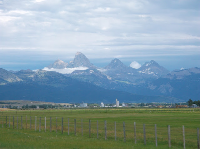
Picture from the Idaho side coming from Rexburg
And the Wyoming side with halos posing as if it was a saint...don't be fooled!
We camped at the Gros Ventre Campground just outside of Moose.
We awoke at 3:30 to pack up and head to Lupin Medows Trailhead (6,732 ft).
Early morning walk in the clouds
Arriving at the Platforms campground
View of the Middle Teton
our firstglaciercrossing
Shortly after the platform campground the trail crosses a moraine field and reaches the Medows (9,200 ft) camping area after another 1.0 miles. At the Meadows stay right of the small log bridge and follow the trail as it begins to switchback up toward Spalding Falls. Above the falls, the trail continues climbing until reaching the Lower and Upper Moraine campsites (11,300 ft).
The Meadow (9,200 ft)
Finding our way through one of the several boulder fields
Above the Upper Moraine campsites the Lower Saddle headwall will appear directly to the west. Use the fixed rope to ascend the class 3/4 headwall section. A short hike above the headwall will end at the Lower Saddle (11,600 ft)
The Upper Moraine(11,300 ft)
The fixed rope...found and utilized!
View from the top of the Lower Saddle(11,600 ft)
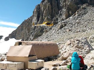
A few minutes after arriving on the lower saddle to taking in the view a yellow and white Search and Rescuehelicopter flew in. Our assumptions were gloomy and we knew someones attempt to summit the Middle Teton did not end triumphant. An ecologistfrom the park, stationed at the Lower Summit, confirmed our fears. They were doing a body recovery from the day before. A man from Victor Idaho had summited the Middle Teton with his two friends. On their decent their partner fell 1000ft to his death. His friends didn't witness the fall, however, another party did. They connected with the victims friends informing them of the mishap. Search and Rescue had been unable to recover the body due to an afternoon storm the day prior, They had returned to finish the search and bring the body home. Around three hours later crews located his body. Inreverencewe took our helmets off, standing on the rugged, unforgiving mountain side, in a moment of silence as we watched the body be lifted in a liter and flown toward Jackson Hole.
Emotions fluctuated from excitement as we reached totrail headto breathtaking aw of the view, fear we had lost the trail, contemplating andreverencinglife, being slap-happy and unable to control our laughter, respect for the elements to agonizing physical pain and a sense of ourmortality.
HERE IS SLAP-HAPPY...
From the Lower Saddle, we hiked north toward the obvious black dike (which the slap-happy pictures are on). The trail split several times, however, we were able to keep forging on with little questioning to the left (west) side of the dike. We were met by a rugged feature called the Needle. We engaged in a class 3 for a short distance until we reached another headwall. The nextobstaclewe were searching for was the Eye of the Needle.
The Eye of the Needle!
Unable to find the eye of the needle (a tunnel-like opening in the rock)or a safe way to the trail we agreed we needed a little moreguidance so we turned to prayer. After the pray was said a female climber popped out of a tunnel five feet in front of us...the eye of the needle...our summit continued.
Continuingthrough the Eye of the Needle, we then traversed north along a ledge until reaching a large boulder which we were required to climb around with a little exposure...
If this isn't exposure
THEN THIS IS!
Reaching the Upper Saddle (13,160 ft)
What we had left to the summit (610 ft) which remained untouched by the three of us....
if you look closely at this picture you can see a climber (in orange) at the top of the rope and another repelling down (in blue). But what you can't see are all the quick moving black clouds from the west forging toward us. A storm we would not be able to beat nor did we have the courage to fight and possible risk life. We chose to enjoy the upper saddle for 15 minutes and head down as quickly as possible before lightning, thunder and hail and rain. We could not have made a more wise choice...LIFE.
Back down to safety at Lower Saddle
Nikelle...tell us how you really feel!
The rain jackets were the result of the storm that overshadowed the Grand
Back to the moraine file from the lower saddle
"This is one mountain I would not disgraced with a poorperformance"
Reminiscent: 20 hours of hiking post Lori's marathon...twobumknees...contemplatingsleeping in the middle of the trail...spouts ofuncontrollablelaughter and hours of silent pain staking hiking...arriving to the car at 11:49pm...sleeping in the parking lotillegally...lostIbuprofen...freezing...leg cramps..."themoleculesand the cells"..."pick the one you like the best"...Lori sleeping outside of her sleeping bag from intense heat wave..
The after effects....sasage toes
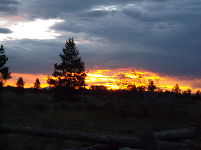
Sunrise the morning after...
Stay tuned for TAKE 2!
Subscribe to:
Posts (Atom)