Friday, January 14, 2011

Big Bend :: Laguna Meadows Trail

One of the highlights of any trip to Big Bend to to hike the South Rim Loop. As much as I wanted to, I really didn't think that I could handle the 13 mile round trip and 1800 foot ascent!

Instead, I chose one of the “feeder” trails that can be taken as part of the South Rim trek. This one takes you the 3.8 miles to Laguna Meadows, hence the name. Longer than the hike on the Lost Mine Trail, I really thought I could make it to the Meadows.

But probably about half way there, I realized it wasn't going to happen. My legs just couldn't handle all of the climbing. Way more switchbacks and a much more difficult trail. Several times I almost quit but a light snack and a drink of water would provide a much needed boost to get me a little further along.

And the views were fantastic. This one is looking towards the Window.

At one particularly disheartening moment, this beautiful bird flew by and stopped in the tree next to me. Its sweet song lifted my spirits and brightened an already wonderful day.

The view from where I turned around. Casa Grande on the right and the Basin to the left, center.

I hadn't seen another hiker all morning until reaching this point. We talked for a few minutes. She said that Laguna Meadows was about another mile down the trail and another two miles to the South Rim. She had left early that morning and had made it to the rim already, going out the other trail to the Pinnacles. She was heading back down on the Laguna Meadows Trail. I was nearly exhausted after just hiking 3 miles or so of the trail. I applauded her and envied her somewhat. But she was young, and trim, and obviously in good physical condition!

But we each have our limits, and I had reached mine on this day. After a short break, a snack and drink of water, I turned around and headed for home.

Photographs taken February 22, ...

What is it?


Speaking of foals. An email friend sent me a photo recently of a foal that is a cross between a zebra and a donkey. Now that critter is really cute. I WANT ONE.

Monday, January 10, 2011

Fashion Friday - It's a pants off!

The last week sawprobably the most exceptional pants wearingThe Cave has ever seen.


Frey Yulepulled off a stunning hibiscus board pant in bluewith a simple lemon chalk bag by Black Diamond and a translucent green denture brush.

jjobrienclimbing votes this look: Flawless


Matt Walpole went all out Acid with awildPsy-Macaw Board Pant,

Dippers chalk bag in Acid Fluff with a deep pink plush lining (Aussie made too, that's nice)

framed in a Wild Country Syncro (way too many gear loops for practical sport climbing, but the added colour and structure works super, don't you think?)


Remember jjobrienclimbing says:Fashion iswhat separates climbers from monkeys.


Saturday, January 8, 2011

It Sounded Too Good to Pass By

Last week, driving along Alabama Highway 72, on the way to Springfield, Missouri we noticed the signs announcing “Coon Dog Cemetery” but didn't have time to stop just then. However, on the way back to Huntsville we made time for a little excursion. Of course, we took the long way around and thought we'd never find it, but eventually it appeared alongside the back-country road.


To be honest, we were laughing and joking about going to a dog cemetery. Now, don't get me wrong, I love dogs and several years ago had to put old Bootsie to rest. It was one of the most emotional things I'd had to do up to that time. So I know how deep the affection can be.


The truth is, we were totally blown away by what we saw when we finally arrived at the cemetery. Nearly 200 coon dogs have been laid to rest in that small plot of ground. Most have markers of some kind – from rustic wooden crosses to fancy stones. And nearly all have flowers, albeit artificial, decorating their resting place. I think my friend Lorene would have enjoyed a stop here...


Only Cemetery of Its Kind In The World.Only Coon Hounds are allowed to be buried.Troop First Dog Laid to Rest here Sept. 4, 1937Please Be Careful With Fire!


Nearly all of the graves are lovingly decorated.


Coon Dog Cemetery came into existence on Labor Day of 1937, when Key Underwood sadly buried his faithful companion “Troop, who was half redbone coonhound and half birdsong, and who was known through out the region as the best. He was "cold nosed," meaning he could follow cold coon tracks until they grew fresh, and he never left the trail until he had treed the coon.”


Track “wasn't the best but he was the best I ever had.”


Ruff Redbone.


Black Ranger “was good as the best and better than the rest.


The variety of styles of markers was fascinating.


Train's grave was originally marked with a brick wrapped in butcher paper.


A traditional marker now marks the spot where Train was laid to rest.


Easy Going Sam was the “Last One on the Wood.”

That's his collar wrapped around the cross.


Looks like the Coon won out over Loud.


There were several markers like this – with the information punched out of metal.

For more information about Coon Dog Cemetery see the “official” website. Also, Travels With Ace has a nice writeup about their visit.


Friday, January 7, 2011

Hallaton - Slawston - Cranoe - Keythorpe Lakes Farm - Hallaton

Thursday 26 May . just under 2 hours and a half walking time - around 8 miles. Up to 600 feet. With Eddie and Barry. A 12 stile walk.


Opposite the village centre with the war memorial and butter cross, a path leads through an archway between the houses. You cross a footbridge and make your way up 'Hare Pie Bank', across the track used on Easter Monday by the Hare Pie and bottle-kickers. Continue along the path, passing the splendour of Hallaton Manor Rest Home on your right. Across two fields and a stream, then another field into Slawston.


Turn right and walk along the main street until another footpath is marked to the left.Across the corner of the first field, then along the edge, a (long) zig-zag round two edges of the next field, through a hedge on the left and over a plank bridge, straight on then right until you reach the road to Cranoe.


At Cranoe Church


Where's the Pink Panther, then?

A few hundred yards into the village, turn right up the hill to the church, and a few yards past it, there is a footpath sign on the right hand side of the road. Take the path up the hill and follow the wide ridge along until you reach a crossing of tracks, with signposts. Don't turn right - this takes you directly to Hallaton down a quiet road/track. Instead follow the Midshires Way, past Keythorpe Lodge Farm, then downhill to Keythorpe Lakes - a large dairy farm. When you see the farmhouse turn sharp left and follow the bridleway, and then the path. You climb gently at first, then more steeply to Hallaton Spinneys and Moor Hill Spinneys up to about 150 metres.

To you right is Issets' Lodge, a huge new house, with a mysterious array of poles. Are they lights, mini solar panels, or beacons to guide a private plane down?


From the top you walk gently descending the ridge, with wide views over rural Leicestershire, down towards Hallaton. Ignore any turn to the left, emerging opposite the Fox Inn and its pond. Just as we arrived a heron flew off. Walk through the village, past a pump, and ? village lock up, back to the central green and Buttercross.

Thursday, January 6, 2011

You either get it or you don't...

As Decemberrolls by I have the urge to get back out on some ice, snow and into the alpine. But it hasn't always been that way. At one point I stopped alpine and ice climbing because so many friends had died doing it. I just didn't have the metal strength to continue in the game.


Too many good friends and relationships were gone like dry wood in a bonfire.

I turned to warm stone to keep my passion alive. And while I have almost none of those physical skills remaining today the mental strength gathered on hard rock now allows me to go back into the alpine or back to work in my shop on those off days when I would really prefer not to.


Tsunami, 5.11b R/X


But it has taken years and a lot of additional support to be where I am at now and be comfortable in my own skin.


Some of us go climbing to find out just how strong we are. And it generally has little to do with how many pull ups you can manage.


Rock climbing is a previous gift that now allows me to climb again in the alpine. But any form of climbing, work or sportcan be your path. Any activity where you choose to test yourself, checkers or may be just getting out of bed can be more than enough.


Hard rock climbing really has little to do physically with winter alpine climbing. But you either get the idea and stylebehind climbs like the B-Y and Tsunami or you don't.


The video is great. Enjoy!


The Bachar Yerian 5.11c R/X from cole gibson on Vimeo.

Grand Canyon :: Kaibab Trail to Cedar Ridge

Our first foray into the Grand Canyon on Monday (April 12th) was a relatively short one; only a mile and a half in length, but it is also had a descent of 1140 feet, starting at an elevation of 7200 feet on the rim and ending at 6060 feet at Cedar Ridge. And, of course, what goes down must also come up! It took us an hour and 15 minutes to make the descent. The trail was in fairly good condition, no snow or ice. But what amazed me was that it took us just 15 minutes longer to make the climb back to the top! And we stopped along the way. A lot. At almost every turn of the switchbacks!

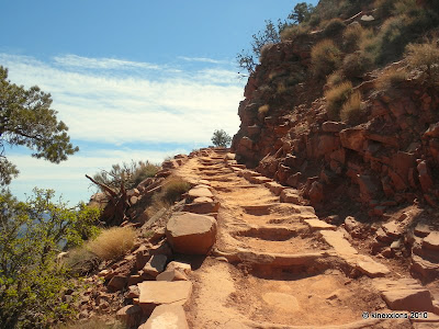
The description of the trail was given as “Maintained dirt trail. Steep. Well defined. Little shade on trail, mostly from canyon walls and dependent on time of day.” That really doesn't do it justice. It's rocky in many places. It had some pretty high steps. It's very steep. It's strenuous. It's challenging. It was fun! Really.

The view from the rim as we were starting out. It was a beautiful day. Sunshine. Blue skies. Cool temperatures just right for hiking with great company.

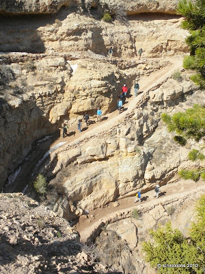
Switchbacks as you come down from the rim.

More switchbacks going down... did I mention that the trail was steep?

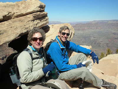
Sue and Fred, taking a break. (Photos of them, and those taken by them, used with their permission.)

Behind me is the section of trail we had just come down, one of the easier sections, I might add. Of course, we were still going down. It didn't look so easy going back up! (Photo by Sue.)

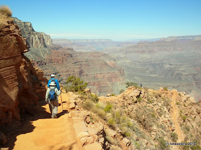
Back on the trail. Still going down.

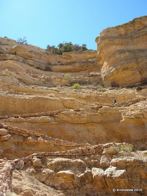
Another steep section showing the rugged condition of the trail. It was difficult to maintain your stride in these sections with the logs across the path.

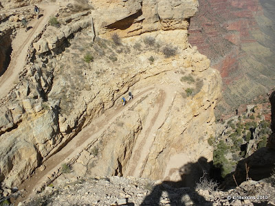
Our destination is in sight! The Kaibab trail continues on past the ridge then winds it's way down the next peak, eventually reaching the river some six miles or more away.

On the way down we had encountered several spots of gusty wind along the trail where we just had to stand still to maintain our footing until the wind passed by. When we reached the ridge plateau, there was a light breeze blowing. It was warm in the sunshine. It was very nice. We walked on out to the end of the ridge, that “pile” of rocks in the center of the photo, and ate our lunch. The wind picked up a little so we moved to a more protected spot and waited for the wind to die down.

During a little lull, we decided to climb back to the flat area. At one particularly narrow spot, the wind came up fast and furious. Sue and I were caught in a gust of wind, I grabbed her arm, not only to steady myself but to steady her as well. We weren't sure that we could keep our footing. It was a bit of a scary moment, it passed, but not soon enough for either of us! If we had fallen off, the drop to the next level was only a few feet, but still, we were more than a little concerned. All of a sudden the wind stopped and we literally ran off of that ledge. With the helping hand of another hiker we scrambled up the last few rocks onto level ground and quickly made our way to a somewhat safer area to settle our nerves.

Looking back at the section of trail that leads down to Cedar Ridge.

The final switchbacks going up to the rim. We're almost there! Thus far on my journey, this was the most challenging and difficult three-mile trek I've made. Was it worth it? Oh, yeah! Would I have made the trek if I had been alone? I'm not sure. I'm just glad that Sue and Fred were there to coax me along the trail. Thank you!